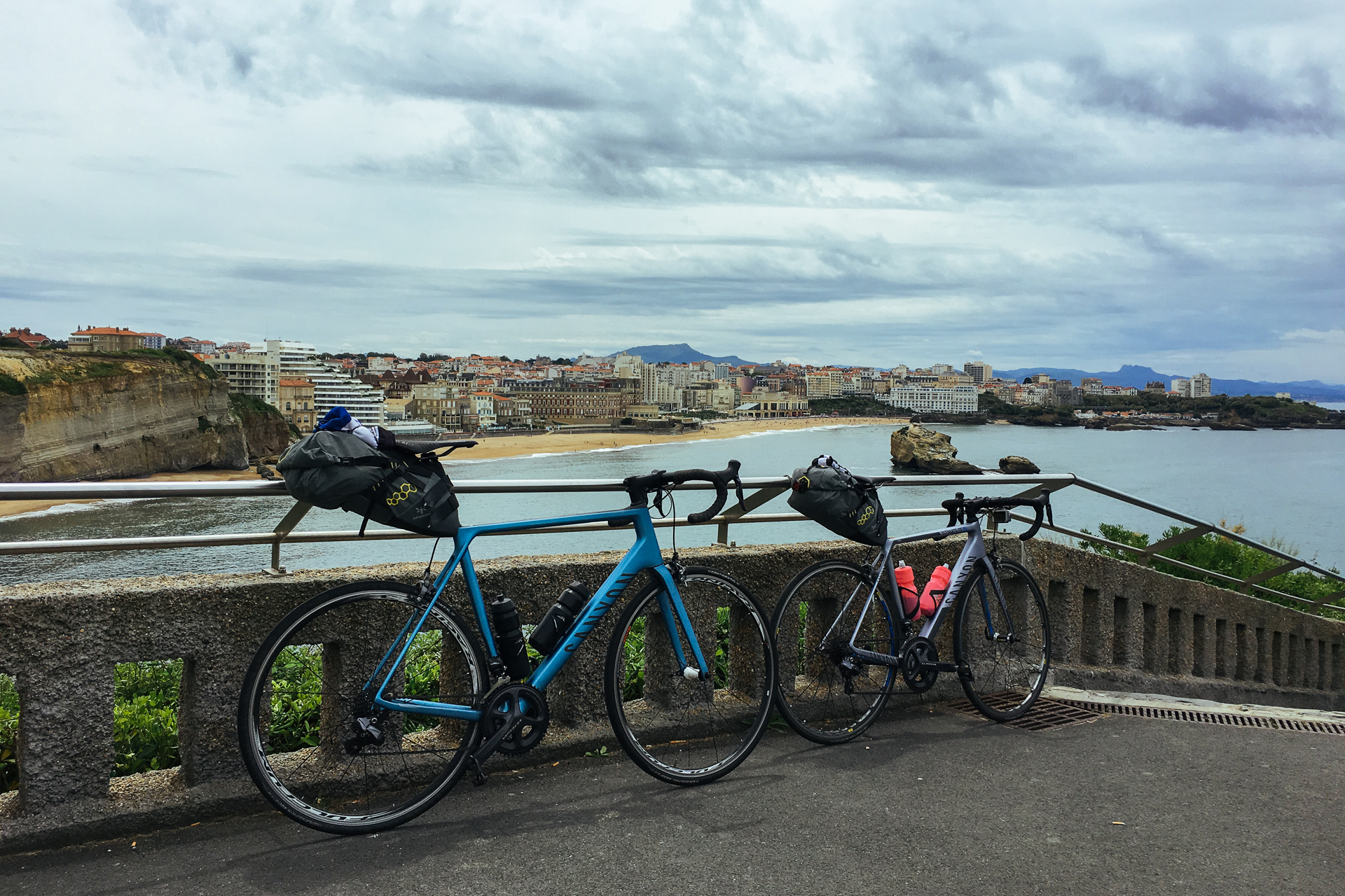
Stage 7: 97.4 km | 2250 m+
Dark clouds were looming low, covering the mountains starting from already a few hundred metres above us when we opened the curtains on Friday morning to check on the weather. Unluckily the forecast turned out to be right, but since we saw this coming already for a few days, we were more-or-less prepared mentally. At least the cloud layer prevented the air from cooling down during the night, so when we departed after breakfast, it was still 19°C. Before heading into the mountains, we rode by a local supermarket to fill our bottles with sports drink, and because a warm-up of 3 extra flat kilometres is always welcome. There we headed back to the centrum, and took the road up towards Arrens.
The menu for the day contained a 1st category double-climb leading up to the Col d’Aubisque (via the Col du Soulor) as the main dish, and a 2nd category climb to the Col de Marie-Blanque for dessert. The first three – 7% steep – kilometres brought us up to the start of a much more gradually ascending plateau that stretched all the way up to the foot of the Soulor. As usual by the time I reached this 9 km-long, slightly undulating section (average 2%), Willem was already gone. The plateau itself was nice; the road led through wide pastures which were covered with hay bales, bordered by forests growing on the steeper slopes on both sides.
We turned onto the first actual climb past the church in Arrens. The road and the scenery was similar to what we had already encountered on the Peyresourde and the Aspin; a narrow lane twisting upwards through grass fields with dashed white markings running along the edges, providing views only occasionally broken by a few trees. Unluckily we did not get to enjoy much of the panorama for long, as a few hundred metres above the foot of the climb we entered the cloud layer. Soon a light drizzle started, the road turned wet, and the visibility together with the temperature dropped quickly.
When I caught up with Willem on the top of the 7 km-long 8% section at the Col du Soulor at 1474 metres, it was only 9°C, and we could barely see further than 50 metres. It was not really raining, but the air was definitely saturated with water, so we had to put on our rain jackets after 6 dry days. We also put on our small flashing lights to make us more visible in the gloomy weather. It is a shame that we could not see anything, because based on the Internet the panorama must have been really beautiful from there, but I think this was not really our biggest concern right there. In any case, from there on we had no views for quite a long time.
The col was followed by 2 km of descending, which in the current weather conditions was painfully slow and filled with way too much braking, resulting in an average speed of 27 km/h on a -5% slope… Yeah, we really did not see anything. Soon the road turned flat then started climbing again. Steep rock walls stood high above us on our left, and similar depths opened up below to our right hand side. We could not tell how deep the void was, since the nearly vertical walls disappeared in the grey mist beyond 25 metres. After 4.5 gradually ascending kilometres and crossing a few short tunnels, the road got steeper again, and the remaining 3 km leading up to the Col d’Aubisque surprised us with an average gradient of 7.5%. To make things more memorable, the so far tolerable rain also got stronger, forcing me to put on even my watertight shoe-covers, and the wind started to blow.
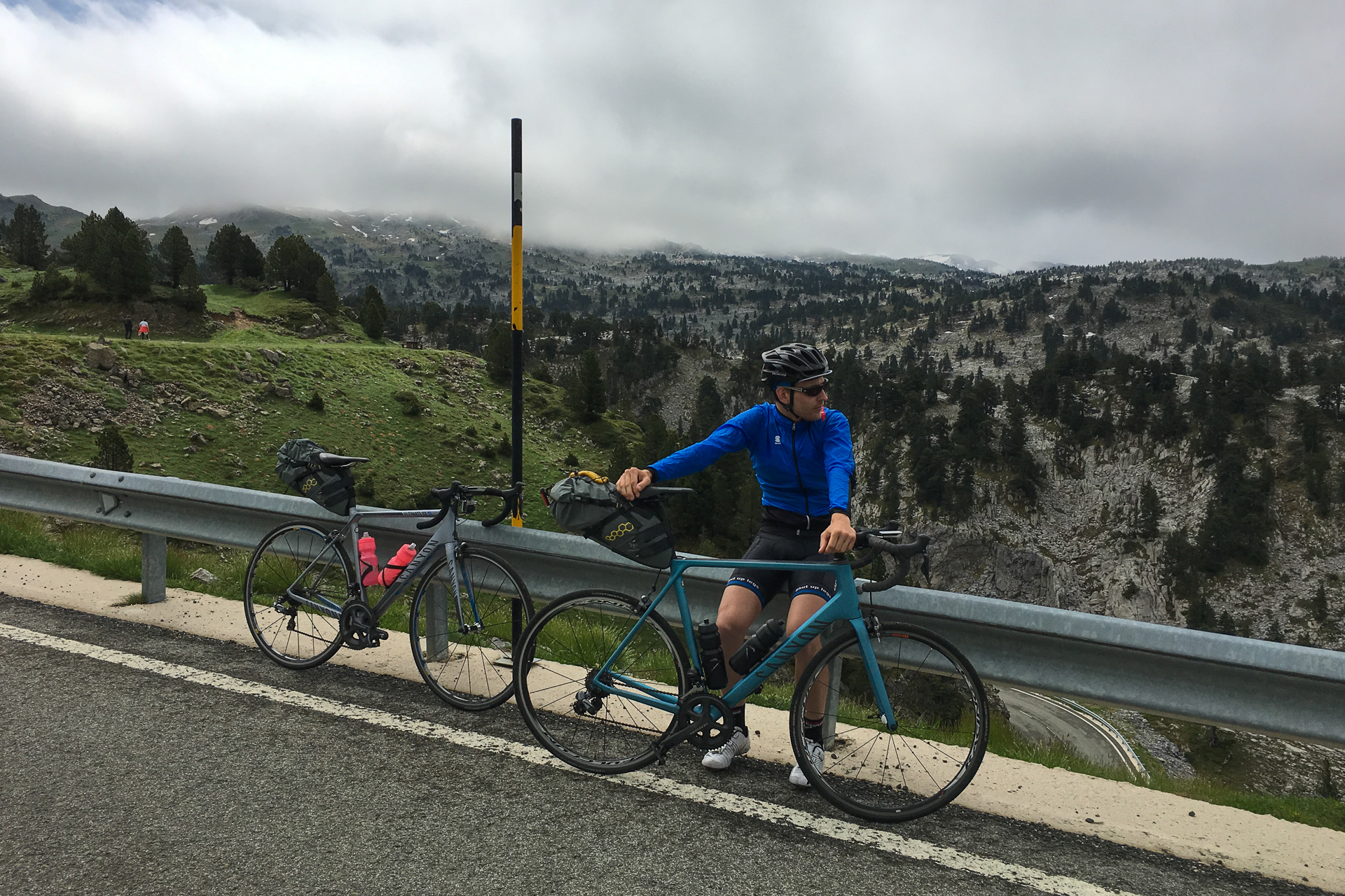
The conditions on the top at an altitude of 1709 metres were as miserable as it gets: rain, 8°C, wind, and a visibility of 15 metres… It sucked, especially because we did not get to see anything from the view. (Google Col d’Aubisque, it is pretty.) I did not think about it there, but I should have put on my gilet under the rain jacket for some extra insulation, because the 18 km descent to Laruns in 10 degrees was the coldest I have felt on the bike since my first day in the Rocky Mountains in 2013 when I got caught in a thunderstorm which covered the road with a layer of ice at an altitude of 2800 metres (there the temperature plummeted to 5°C, even though it was 34°C on the plains, and 15°C nearing the top of the climb before the storm broke out). We were both very cold, but I think Willem suffered more, shivering due to the horrible wind-chill during the descent. I am sure he already regretted not putting his rainproof overshoes on. (I don’t know what was he thinking when he made that decision.)
It was so bad, that when we finally reached the bottom of the valley, we kept pushing hard even on the flats in order to warm up. That was one of the rare occasions when I did not want to stay in Willem’s slipstream at all. Luckily it was not raining anymore below the cloud layer, and the rain jackets themselves did their job perfectly earlier, so we were at least not too wet on top of everything. By the time we arrived to the foot of the next climb in Bielle after 8 basically flat kilometres, we were feeling much better again, and we could get rid of the jackets (as it was dry and 15°C).
The sign at the beginning of the climb stated that we would have to face 11.2 km at an average of 5.2%, but it was more complicated than that. It started with a 5 km long, steady 8% ascent leading up to a beautiful plateau, situated just metres below the swirling cloud layer, and surrounded by modest peaks covered in lush forests. A large flock of sheep just got off the road when I got up there. For the next two kilometres the road did not reach a much higher ground as it crossed the pastures, but it climbed just enough to disappear into the cloud layer as soon as the next steep section started where it entered the forest. At the same time rain began to fall again, so I put on both my gilet and my rain jacket (leaving the latter open for the climb), knowing that it would most likely only get colder and wetter towards the col.
Despite the conditions, there were quite a lot of other cyclists on the mountain, mostly riding in the opposite direction. The first kilometre in the forest was a steep 9% climb, then the road levelled out and stayed flat for the following two. The last sign (showing the elevation, remaining distance, and the gradient for the coming section) before the top displayed such a ridiculous percentage (something like 18% if I remember correctly), that I had to let a few juicy Hungarian swear-words go out loud. Luckily, the value was totally incorrect, the reality was definitely something single digit.
When I finally reached the Col de Marie-Blanque at an altitude of 1035 metres, it was completely deserted. Rain was pouring down almost silently, and I could see thicker and thinner cloud layers slowly floating across the road. I was not surprised that Willem was not waiting for me there. In a sense it was very special, being there alone in the quiet, listening to nothing but the rain drops, watching the surroundings quickly disappear in the grey mist beyond a hundred metres. The descent to Escot was wet, but literally straightforward. Willem was waiting there, refuelling under a small roofed shelter, standing just next to the information sign describing the climb to the Marie-Blanque.
I also ate one of the few real energy bars from the small PowerBar collection that I had brought along specifically for hard moments where normal snacks just would not be enough. We still had around 15 kilometres to go, but the road we were supposed to take had been clearly just resurfaced, as the fresh dark layer of asphalt was almost fuming in the rain. After a manual temperature-check (a.k.a. touching the ground) we decided that we would try to ride over it anyway. After the first bend it became clear that this was not going to work after all, because not only got the asphalt noticeably warmer, but the road a few hundred metres further was blocked by heavy vehicles and a team of workers laying down the fresh, hot surface. There was no other option than turning back and taking the road on that side of the valley, which meant a bit of extra up-and-down and 3 additional wet kilometres, which non of us was really missing from the day.
We were pedalling relentlessly towards the finish, with water seemingly coming from everywhere. The last small hill (surprising us with an actual mini-serpentine) before rolling into Arette was slightly demoralising, but we were both very glad when we finally arrived to the hotel. After getting the keys to our room we put away our bikes in the office of the owner (who had his own electric MTB there), and got busy with our post-ride checklist, which contained a bit more shoe-drying than usual – especially for Willem. Our saddle bags survived the rain with only minor water damage, but since all our clothes and electronics were in an extra protective plastic bag inside, everything came out perfectly dry.
Afterwards we cleaned the bikes a bit in the garden with a hose, and even put on fresh chain oil (so carrying a tube of it over the previous cols finally payed off). We could already tell by running our finger along the edge of our rims, that the fog-enforced prolonged braking down the Aubisque ate away a noticeable amount of the material. Since it was still early in the afternoon for a proper meal, we ran across (as it was still raining) to the grocery store to already buy the drinks for the next day, and to get some chips and chocolate to survive the rest of the evening. Then we got dinner in the only available local tavern, which had a surprisingly nicely decorated restaurant area, serving very simple, but large, filling local dishes.
It was also the evening of the opening game of the UEFA Euro 2016, but the signal on our TV kept dropping out, so we did not see the French win. We were more busy checking the weather forecast and the radar picture, pondering about the chances of getting soaked during the queen stage the next day. We analysed the profile of the next étape every evening, but that was the first time that I was a bit anxious. I told Willem that we would just wait and see how things turn out on the next morning, but I was quite worried that if the weather does not improve then we might have to skip climbing over to the Spanish side and take a shortcut staying at a lower altitude in France. It was unlikely, but I like to be prepared for everything… In any case, it was still raining when we fell asleep.
Stage 8: 133.8 km | 3500 m+
Our wildest dreams became reality on Saturday morning; not only was it not raining anymore, but patches of blue sky were visible between the clouds, and even the sun made it through one of these encouraging gaps. We were back in business as my bad thoughts about a shortened stage immediately vanished while catching the first glimpse of the much-improved conditions. The legs were also feeling OK, especially considering that we were on the road for 7 days without so much as thinking of a rest-day.
Being optimistic was definitely necessary, because it was the queen stage of our Trans Pyrenees ride waiting for us that day, with the following series of climbs: a HC, a 3rd, a 1st, a 1st, and a 3rd category ascent… The elevation profile and the raw stats foreshadowed a stage that would have been tough enough even as a separate one-day grand fondo event, but we had to tackle it after a week of riding through the mountains. We got going with these thoughts after a relaxed breakfast. The weather was perfect (18°C, no wind) and the roads down in the village were already dry.
The first col of the day was our second and last hors catégorie climb (after the Tourmalet): 25 km at an average of 5.6%. The first 8 kilometres were easy at ~2%, first crossing the fields around Arette, then passing through a few narrow gaps between the surrounding steep slopes leading into the valley that we would follow later on. Here we could still ride casually next to each other and chat while spinning at an optimal RPM. We passed the first elevation/distance/gradient marker 19 km from the top, still showing only an easy 3% till the next sign. The road already entered the forest by then, but for a few kilometres the steep slopes to the left stayed free of trees, but instead they were covered with a dense layer of dark green grass that was wet from the morning dew, shining in the low sun, and broken only by a few lonely rock formations balancing over the valley.
Then it suddenly became steeper – 10 km followed at an average of 9% -, and as usual, the distance between me and Willem started to grow. I still managed to catch up with him 5 minutes into this section because a large group of cows was being herded up taking the whole width of the road, and it took a bit of work from the herders to let us through. Even with the push we got from a friendly farmer, I could not stick with Willem for too long, and I lost sight of him soon afterwards as we reached the first real hairpins. As we climbed, the clouds above us got thicker again, and the humidity rose noticeably. Upon entering the pine forest at an altitude of around 1000 metres, the air also started to cool down, so when I reached the end of the steep section a good 350 metres higher (in 10°C), I stopped for a few minutes to put some extra clothes on (arm warmers and a gilet).
The next 3 kilometres surprised me with an easy 4%, even including a short downhill section through a low-hanging cloud-layer, and some very different scenery. The road curved across a wider, grass-covered area first, then waved further up around small rock-islands that stood a few metres tall on both sides, serving as elevated platforms for the pines that were growing on them. When the trees disappeared later on, these grey stone-formations got more prominent, and without the protection of the vegetation, their surfaces and edges became much smoother from erosion. Here two more steep sections followed; 1.5 km at 8% climbing through the outskirts of the ski-village, and – after a small downhill – another 1 km at 8% twisting higher through the grass and stone covered slopes (and even a few patches of snow here-and-there).
The last two hairpins were very painful after almost two hours of climbing, but then the final few hundred metres were much more gradual, and I could see Willem from far already before rolling through the imaginary finish line at the Col de la Pierre St Martin at an altitude of 1766 metres (a good 10 minutes after him). We were happy to be on the top, since that meant that a significant percentage of the day’s elevation gain was completed, the longest climb was done, and most importantly, we were still dry. As it was only 8°C on the col, we had to put on our jackets there.
We started the descent into Spain immediately after taking a few pictures, hoping to get out of the cold as soon as possible. There were more pine trees growing on the otherwise thin patches of soil on the grey, rocky Southern slopes. The first three kilometres of the descent twisted across this landscape, including even a 270° turn where the road curved around and passed under itself. This was followed by another 3 km of basically flat section, leaving the narrow stone-walls behind arriving to a broad, grass-covered ridge running along the border. We had to stop here for a few pictures, because we reached the edge of the cloud layer, and a full 360° panorama opened up around us. We could see the last peaks reaching above 2000 metres in the Pyrenees to the West, and the blue skies above Spain to the South.
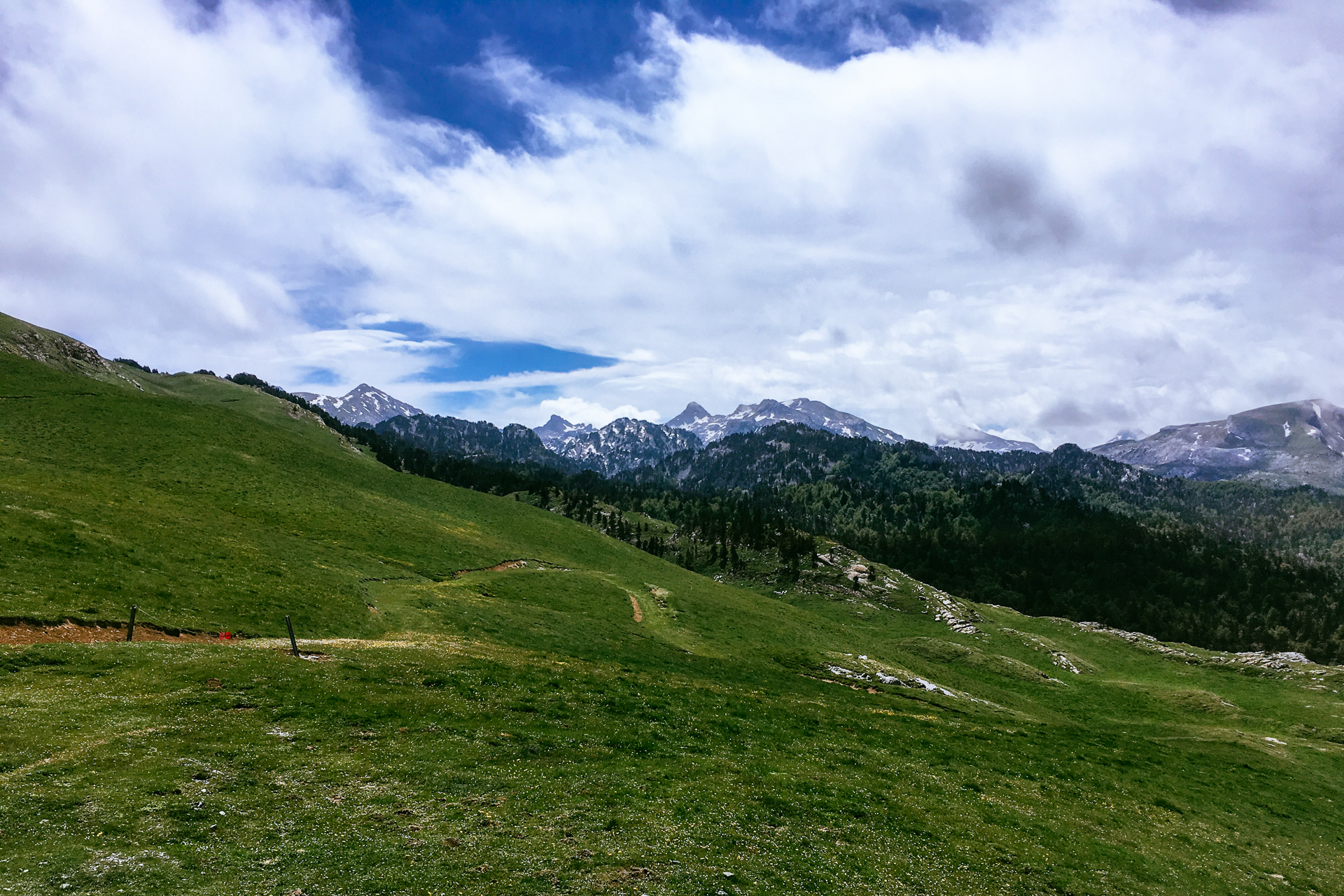
The next 8 km descended at an average -7%, and it was probably the most mentally recharging part of the day, if not of the whole journey. It was finally sunny, the road was broad, the surface was smooth, the traffic was non-existent, and we were flying down effortlessly at speeds above 70 km/h in the straight sections. In the middle of this section a serpentine got us down from the grasslands into the forest through 7 hairpin corners. The colours were amazing; the deep blue of the sky, the green of the grass, the yellow patches of the blossoming bushes, and the dissolving white clouds provided a photo-perfect background. Suddenly life seemed so much easier, and the queen stage much less worrying.
At 1000 metres the road left the steep section reaching the broad grassy basin of the valley below, which is most likely the byproduct of a glacier that covered the slopes to the East thousands of years ago, and was later on filled up and flattened by the receding ice sheet. There is still a fast-flowing mountain-stream that remains, probably shaping the basin year-by-year a little further. For the coming 12 kilometres we followed the narrowing valley on a moderate -1.5% slope, which continued in a narrow gorge through the forest later on, before reaching the lovely village of Isaba.
Our actual route would turn right just before entering the town, but we decided to make a short detour to get something to eat and drink. The last few metres were pretty steep, but luckily we managed to find a bar that was open and where they even served some food. I got two small sandwiches, while Willem got a small portion of patatas bravas. When we decided to continue the sky was cloudless, and the temperature rose to almost thirty degrees, so our vests and jackets got packed away. A very quiet road led us towards the Northwest through a small valley, surrounded by a mixed forest, but it was quite boring compared to what we had seen earlier that day.
After 9 km at 2%, a 2 km-long 7% ramp took us over the small pass of Laza at an altitude of 1129 metres. We immediately rode further (after a short pee-break), descending to a bit below 900 metres in 3.5 kilometres. There were some nice views from here, looking up towards the North and the Northeast, where we could see a thick layer of clouds flowing over the mountain range from the French side, and dissolving while rolling down above the Southern slopes. Although it was really beautiful, it also warned us that the weather over the border was still less hot and sunny. Of course that was exactly the direction we were heading to.
As soon as we reached the road below, the descent turned into ascent; the next 10.3 kilometres followed at an almost constant 6.5% towards France. It was nice to climb at a steady pace, and the landscape was also pleasant. During the first third the road was twisting through a not too dense forest which was frequently interrupted by patches of grassy meadows that provided great views to the cloud-waterfall to the North. Then two kilometres of forest followed, where we realised that there was an actual grand fondo happening in the opposite direction (called the Irati Xtrem) as riders escorted by safety-motorbikes flew by clearly racing down the mountain.
We passed the tree-line at 1300 metres. From there the road climbed steadily and generally straight North, not far below a North-South oriented grassy ridge. There were a few vultures circling above to our left, probably staring at the few weak-looking (but simply freshly-shaved) sheep lying at the side of the road, and a large chunk of dark cloud flowing down the mountain from the right, just in front of us. The view was magnificent, up until we passed the last hairpin, when everything vanished in the grey haze a kilometre from the top. A hundred metres further I had to stop for a few seconds, because the road was just about to disappear in a dark, cloud-filled tunnel, so I really had to put on my lights for safety. By the time I reached the Port de Larrau at 1578 metres, the visibility dropped to basically 10 metres, thick drizzle started to fall, and the temperature was also plummeting towards the single digits (reaching 7°C a few minutes later).
I stopped at the side of the road to put on all my warm clothes, but I had to fight a bit for my jacket against the strong wind. In the meantime more and more participants of the Irati Xtrem were reaching the top (which was the end of a timed section) from the other side. Despite the challenging conditions, there were a lot of supporters out on the mountain, cheering loud for every rider. This large turnout was very nice, but made the 14 km-long descent to France slightly more annoying than it should have been. First of all, the visibility was already so low (even worse than the previous day down the Aubisque), that I could not let the brakes go during the first half until reaching the cloud-base (further eroding my poor rims), but with the huge traffic of cyclists coming up against me, often taking the full width of the road, I had to shout out a few times to make them realise that it was not a one-way road after all. Then when I could finally see further than my front wheel – upon reaching the lower half – I still could not enjoy flying through the consecutive hairpins much because there was simply not enough space on the road. It is a pity, because the road was very nice and technical, and the view was also pretty over the green mountains of the Basque country.
Willem was waiting for me in Larrau, also slightly pissed about the traffic jam we had to endure earlier. We had to descend another 2 km from there until reaching the bottom at around 500 metres, where we stopped for a few minutes before jumping onto the next climb. And OMG what a climb that was… 10 km at an average of 8%, but including a 5 kilometre-long section at 12% ending only a few hundred metres before reaching the top. It was simply brutal; there were hairpins where I could barely push through, we had to stop for 15 minutes 1.5 km into the steep section because an ambulance-operation was blocking the road above, and on top of everything it was also raining. Not the drizzle we had on the previous peak, but proper rain. I had to stand out of the saddle much more than I normally prefer to, and both my speed and average cadence were in the miserable region. Each 100 metre seemed to take forever. I suffered so much that it was not fun anymore.
When I finally reached the top, the only positive thing I could think about was giving the middle finger to the Col de Bagargi (1327 m) sign. That was at least funny :) Willem was already busy putting his water-tight overshoes on sitting on the covered terrace of a small wooden house when I arrived, but he was also clearly getting tired. He did not say it, but I could tell from the lack of smiling or joking. The descent started in 6°C. It was extremely wet and slippery, so we had to take each of the hairpin curves very carefully. For the last kilometres we got under the cloud layer again, thus we could enjoy the view of the lush green hills for a short while. But the dry weather and the good visibility did not last long, because after 6.5 km, the road turned uphill again, climbing back into the rainclouds. I was totally dead here, with no remaining energy to push at all. Rain-curtains were moving across the 2 km-long 6% ascent, and we crossed the Col de Burdincurucheta at 1135 metres in miserable conditions.
We did not stay long. The following descent started with a series of hairpin curves, then continued along the ridge to the Northwest. Somewhere here we left the cloud layer for good, and since the road was miraculously pretty dry, we could finally do some high-speed descending looking over the green Basque landscape. 9 kilometres below the last col, we reached the bottom of the valley (at an altitude of 330 m) after passing through a second series of narrow turns in the forest leading down from the grassy ridge, and surviving an uncomfortably-close encounter with a few cows.
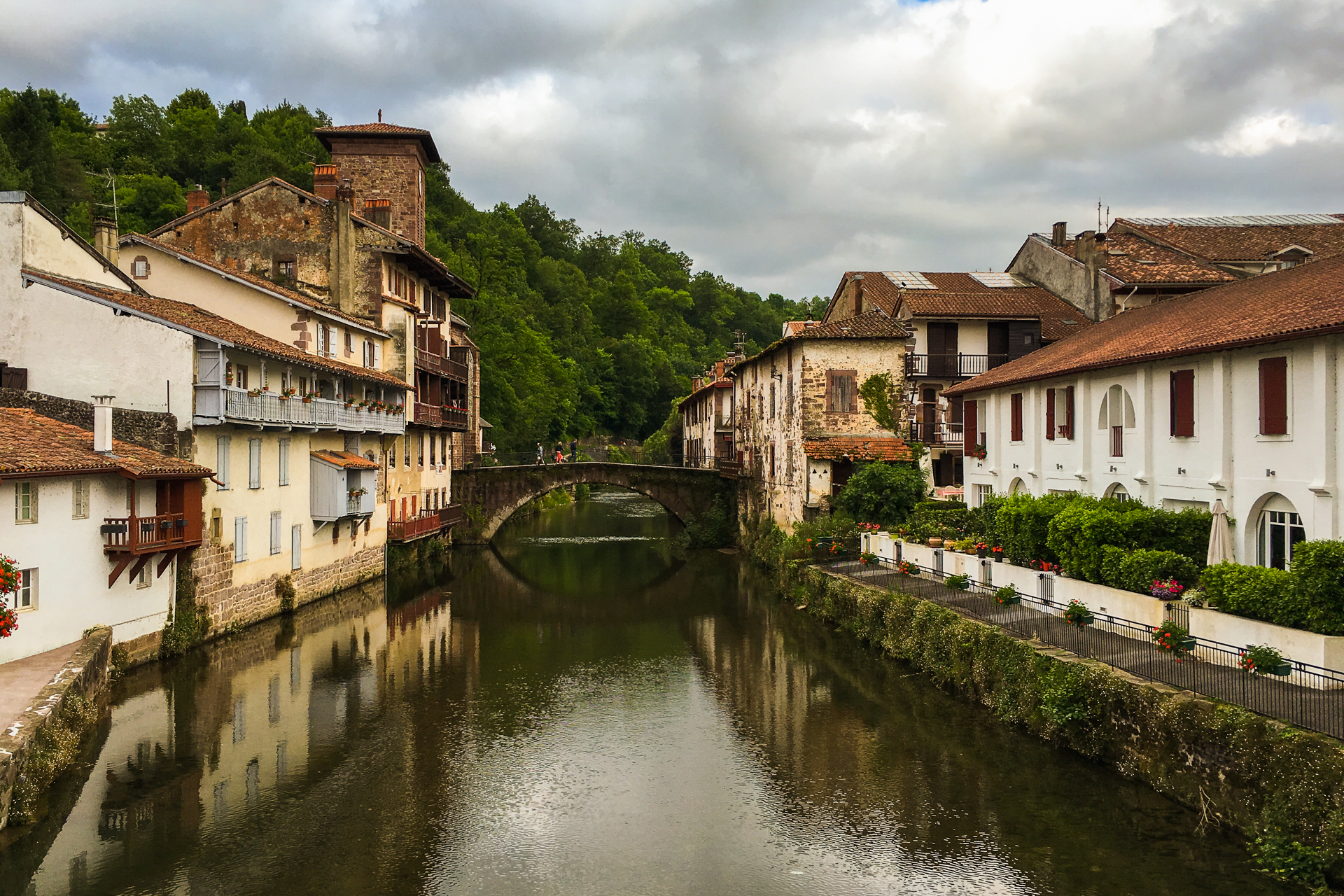
The last 15 kilometres stayed more or less level (-1%). We passed a series of villages with unpronounceable names, then left the main road for a final roller-coaster (which was much nicer than the big road, but the extra unexpected short climbs did not make us happy at this point) before a short descend landed us in front of our hotel in Saint-Jean-Pied-de-Port.
That was a huge moment for both of us. We survived the queen stage, the last hard day before the finish. It was a truly epic ride, and we were strong enough even after seven days in the saddle to handle it. We knew that the following day we would reach the finish for sure. We must have felt the same way as the pros feel after 20 stages on the Tour de France, knowing that now they will surely make it to the Champs-Élysées. We were tired – even Willem (maybe for the first time) -, but very happy. We checked in, put away our bikes in a comfortingly safe-looking storage area, then occupied our room feeling all-triumphant. It was definitely the nicest hotel we had in France, and we appreciated the comfort very much after such a hard day.
After going through our post-ride rituals we immediately went for food. The city was very pretty, every house is painted white and (brownish) red, which gives a clean, organised look to the streets.
We checked out quite a few restaurants before sitting down at a nice terrace just next to our hotel, which even had the evening’s football game on display. We spent so much time on the road (8 hours and 15 minutes with stops included), that this was the very first evening when we did not have to wait for the restaurants to open. It was very nice sitting there, having good food, knowing that there is only one more day to go, and not having to worry about anything while enjoying the evening sunshine. As usual, falling asleep was not an issue later on.
Stage 9: 88.7 km | 1341 m+
Sunday morning dawned at us under cloudy skies, but with no chance of rain for the day. Our bikes were still dirty from the ordeals of the previous stage, but we could not care less anymore. The rims lost again a noticeable amount of material from the prolonged breaking, but everything seemed to be still well within the safety-limits. The chains were still running smooth thanks to the hydrophobic (crazy-ass expensive) chain-oil that I carried over the Pyrenees, and the rest did not matter as long as everything was quiet. Even though the day would be easier, there were still two climbs that had to be done, and we were supposed to pick up the rental car at four on the afternoon, so we left not much after ten.
We passed by the supermarket to fill up our bidons with sport drinks for the last time, then set off to the West. The first 12 km crossed the Basque countryside generally level, containing only a small hill-climb before rolling into Saint-Étienne-de-Baïgorry. In the centrum of the scenic red-white-green-coloured town we took a right turn to start our last 2nd category climb. Willem decided to take it easy on the last day and he stayed with me during the whole 7.5 km-long ascent (at and average 6.5%). It was a nice narrow road climbing higher-and-higher around at least five small, grass-covered ridges, twisting slowly from one side to the other. My legs were not very fresh, but the steady gradient was very much to my liking. It took us a bit more than a half hour to reach the Col d’Ispeguy at an altitude of 672 metres.
The view was nice, although the overcast sky turned the otherwise vivid shades of green a little pale. The downhill into Spain was much longer than the climb (12 km), and started on a narrow, steep serpentine containing ten hairpins, after which it straightened out and continued more gradually. Then we turned North on a larger road, and started the last categorised climb (a 3rd category one) of the Pyrenees. Most of the 7.5 km-long ascent lead between trees that blocked the view, and despite the easy 4.3% average gradient, I kept dropping behind Willem. Although the official elevation of the Col d’Otxondo is 602 metres, we reached the col-sign at 570 metres, and a post-Pyrenees internet search showed that the latter is indeed the correct value. We saw two other guys here riding in the opposite direction with the same saddle bags, and immediately thought that they must be doing a similar ride to us. (Based on another post-Pyrenees internet-investigation, this was also correct.) Just like at the first real col, we have taken a picture with the col-sign here too.
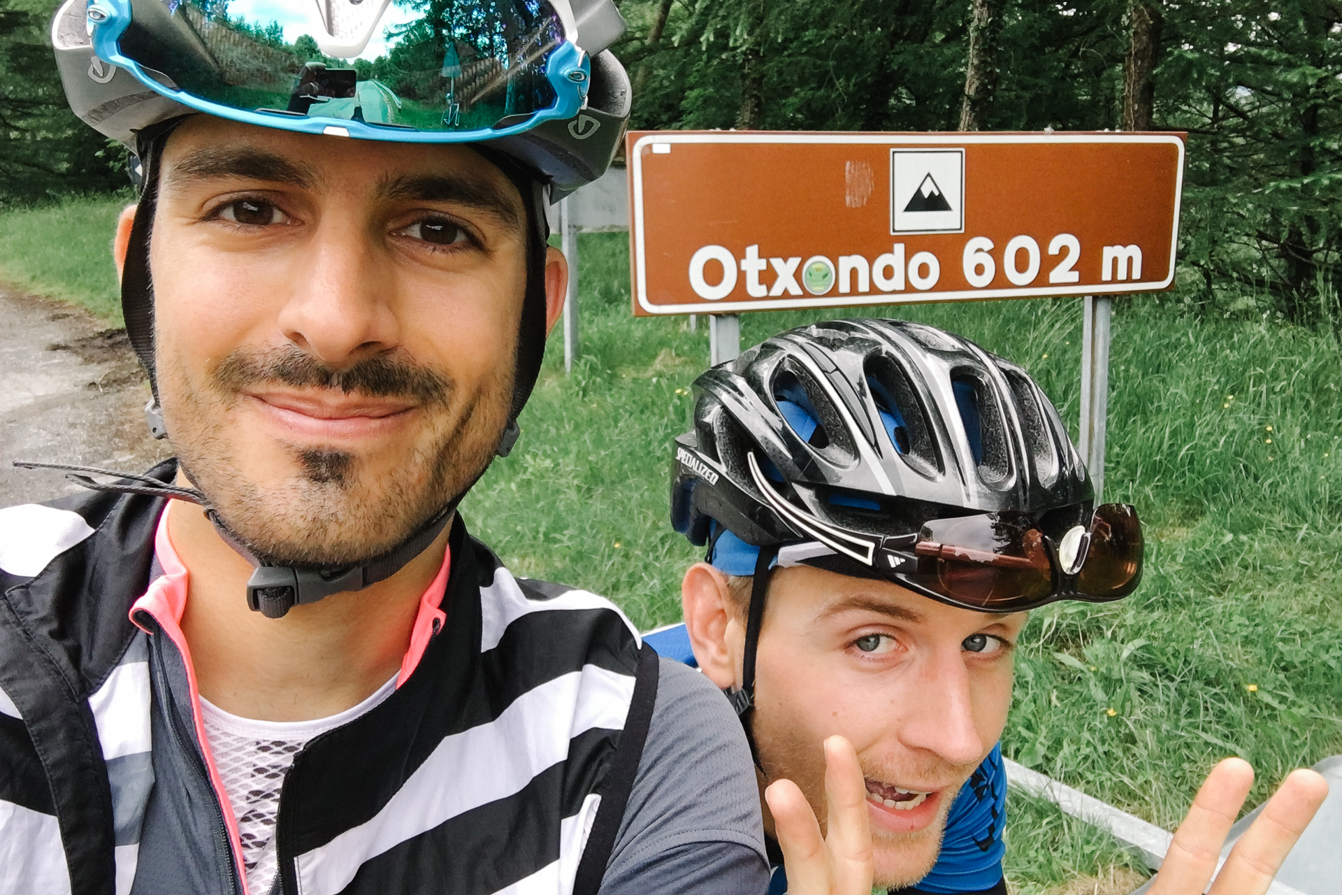
Looking at the two photographs, we are as happy on the second one as on the first, but with a bit more facial hair :D The Atlantic Ocean was already visible in the distance from the descent, but Willem was more busy going down Froome-style than looking around, so he missed the view. 10 km later we crossed back into France. The landscape has changed a lot, we left the mountains behind, and we were pedalling through a countryside that could have easily been somewhere in Belgium too. Willem was pushing quite a good pace – we were going well over 30 km/h on the flats – while I was chilling/surviving in his slipstream.
Another ten kilometres later we had to climb back a bit (1.1 km at 6%) before pushing through a mix of fields, meadows, and small forests over a slightly undulating secondary road (trying to drop a local cyclists) before reaching the first houses of our final destination a good 16 km further. I would have taken this section a bit slower, but my crazy travel-buddy thought there was nothing better than a bit of power-training after 8.5 days in the Pyrenees… :D The following 6 kilometres led deep into and across the fancy centre of Biarritz, where we passed an uncountable number of hotels, casinos, and small castles – or big villas – before reaching the lighthouse overlooking the bay. There lied the virtual finish line of our Trans Pyrenees ride, so we stopped for a while to appreciate the view and what we had just achieved.
We celebrated with a last fist-bump, a recurring element that was introduced by Willem at the end of the first stage. Then we decided that we would first bike to the Airport (which was another 5 km further) to pick up the rental car, and get something for lunch only afterwards. That was a first in my life, arriving to the terminal by bike and walking in wearing cycling shoes, but nobody seemed to be bothered by our sight (or smell).
We changed into normal clothes in the toilet, then got the keys of a much bigger car than what we expected, so loading the bikes in was a surprisingly easy task. On the other hand, it was an automatic car, and Willem needed a bit of explanation about driving without the stick. In the beginning he wanted to shift all the time, and when the leftmost pedal is not the clutch but the brake, then pushing it while going fast is not the best idea. So I had to hit him a few times when he removed his right hand from the wheel :D
The highway passed pretty close to the Pyrenees for quite a long time before turning up towards Toulouse, so we could still say goodbye. The mountain range seemed magnificent, rising as a massive wall behind the plains to the South.
This sight made us appreciate the magnitude of our accomplishments of the past nine days even more. A good 300 km (and only one accidental braking as Willem attempted to shift down while driving off the highway) later we arrived to the Airport of Toulouse, where we dropped off the rental car. Then we biked to the hotel where we left our car 10 days earlier. Navigating there without our Garmins was not so straightforward, but thanks to Google Maps we managed.
We immediately packed the bikes in neatly to be fully ready for the homeward journey the next day, then drove over to another hotel where we would spend the night. (Yes, it was much cheaper to book two different hotels in Toulouse for the first and last night, than taking the same one.) After check-in, we got some asian food in the centre, and unlike the previous evenings, even I had some wine. Or maybe that was already after the queen stage, I don’t remember anymore. We might have watched some football before falling asleep, but non of us payed much attention.
The next morning we made it to breakfast as early as possible, then drove home with the cruise control set to the maximum allowed speed. We stopped only twice to grab some food (because I love shopping at gas stations), and had a pretty uneventful journey, except for a bit of traffic through Paris, and almost running out of fuel half an hour from home. But we made it after all, and in no time I was already half asleep lying across our couch.
These days in France and Spain were definitely one of the coolest things I have done in my life. I am very glad that Willem was crazy enough to come along, because I would not wanted to do this alone. Transcontinental Race next? :D