Spring in the time of Covid-19

This spring (and summer) turned out to be very different than planned, due to the global coronavirus pandemic. Just a few days after my last flight lesson, Belgium went into lockdown, working from home became the new norm, and social distancing undoubtedly established itself as the word of 2020 in an instant. Luckily (or rather thanks to the hard work of scientists, health care personnel, and the willingness of politicians to listen to these groups) we managed to flatten the curve before the health system got overwhelmed, and we are basically done with the measures as even bars and restaurants reopened two weeks ago, and since last Monday international travel is also allowed again. As the virus is still present, and there is no vaccine yet, it seems like life will have to go on in a quite different way compared to how things were used to be before Covid-19, with face masks and keeping a safe distance whenever possible.

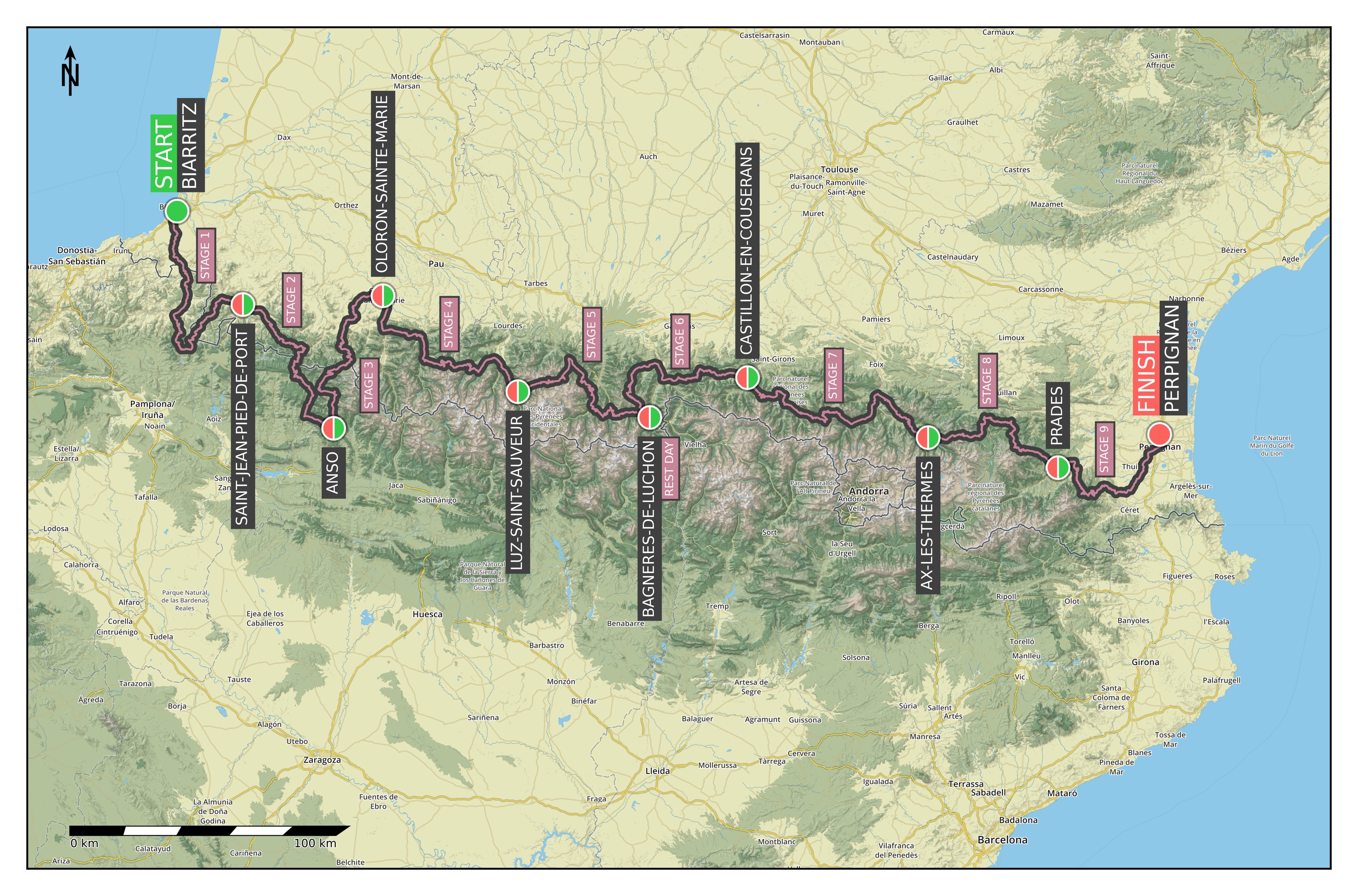
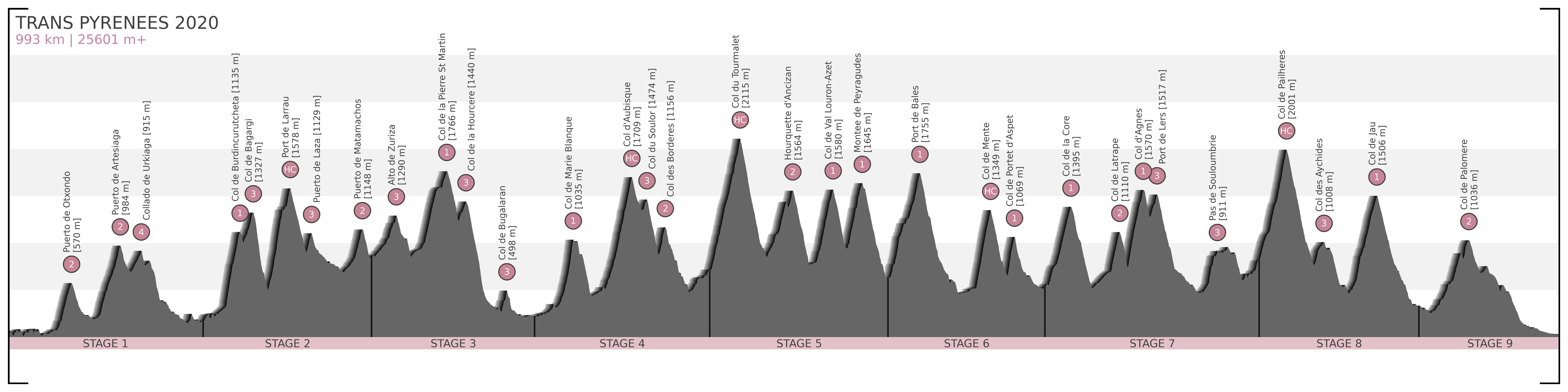
While we had no physiological or financial issues (I can work as well – if not better – from home as from the office, and there is enough work to do), mentally these weeks (especially early on) were really not easy. In the beginning my hypochondria was messing with my head way too much, causing large swings in my mood and productivity, which got better only by limiting my news intake, and when hospitalisation numbers finally started going down. Initially I could not even fully enjoy my occasional bike rides outside because of my bad mental state. Luckily individual cycling (and running) was always allowed (and even encouraged), because I am pretty sure I would have gone really crazy without that… But holiday plans (including the so thoroughly planned and booked Trans Pyrenees ride) had to be cancelled (and everything is was too uncertain to start making new ones), we could not go to restaurants, there were no flight training, Liverpool FC was halted on the way to their first Premier League trophy, and I was not even allowed to drive to the Ardennes for a ride :( Mainly 1st world problems, but still, a big negative change in everyday lifestyle is difficult no matter the baseline.

After the initial shock, we slowly got used to the new situation. The exceptionally dry and warm weather (average temperature of my rides in April was 20.2°C, which is several degrees over the historical average, and this April-May was the driest April-May in Belgium since the beginning of measurements) definitely helped by creating plenty of opportunities for biking (and since I work 4/5th as of February, I have more free time in general in any case).

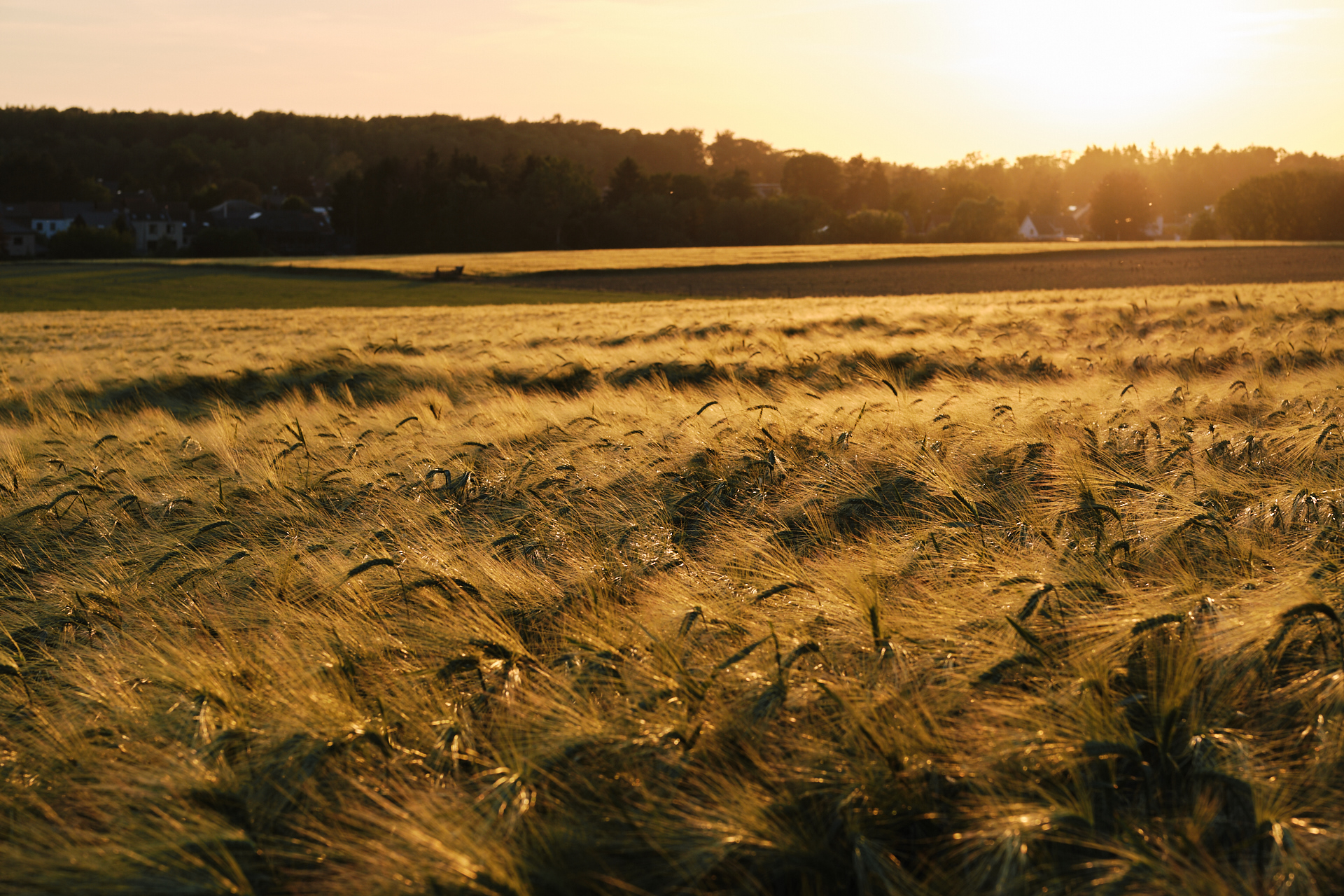
So while my big sportive goal for 2020 suddenly disappeared, I still continued with the training that I started at the beginning of this year (wanting to get my earlier cycling fitness back, and simply wanting to do something else besides sitting in front of the computer). I tried to keep my rides interesting by always picking a different route (while avoiding the busy paths along the waterways), and by participating in small challenges on a few selected road segments. After my burnout last year, I really enjoyed being on the bike again, and I tried biking without looking at the numbers most of the time (so biking for the good feeling, and not to achieve a given amount of kilometers a week or month). Even though I try to not not concentrate on the plain numbers anymore, having completed all main monthly Strava challenges (bike more than 1250 km, with more than 7500 m elevation gain, and including at least one 100 km ride) in April and May, and even getting a few KOMs (back) is something I am happy about (plus it seems like my cycling fitness level has just reached its all time high too). I have also visited some new places, like the spiral bike path looping through the trees and the bike path crossing a lake (in a way that the road is under the water level while your eyes are in line with it) in Limburg, or the geographical middle point of Belgium, and the West side of Brussels. The open road (or gravel path) was also the only place where I could meet up with a few friends when it was already safe to do so, and some of the best rides were these social evening spins just before sunset. I expect that now that flight training is restarting I will bike a bit less, but as we are allowed to take the car to ride somewhere else since last week, I hope to get back to the Ardennes and bike further away from Leuven more often in the coming months (which already started with a nice outing to Luxembourg on Sunday).

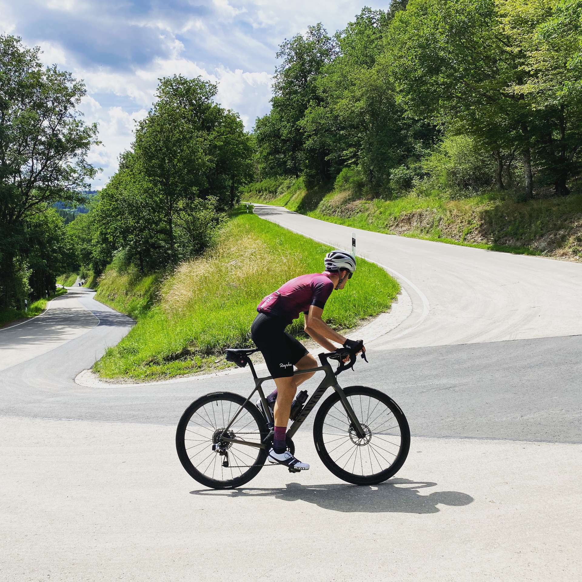
I have been riding with my beautiful steel bike too a lot (already more than over the whole past year), not only because it is a very nice bike, but also because I had to miss my Endurace for two weeks… The reason: the frame broke under me (where the front derailleur hanger is screwed onto the seat tube), just 500 m from home, but luckily without me crashing. Fortunately it cost me only 120 EUR to get a brand new replacement frame (instead of 2600 EUR which is the actual price of a new frame), as the bike was still covered by the 6 year guarantee of Canyon.

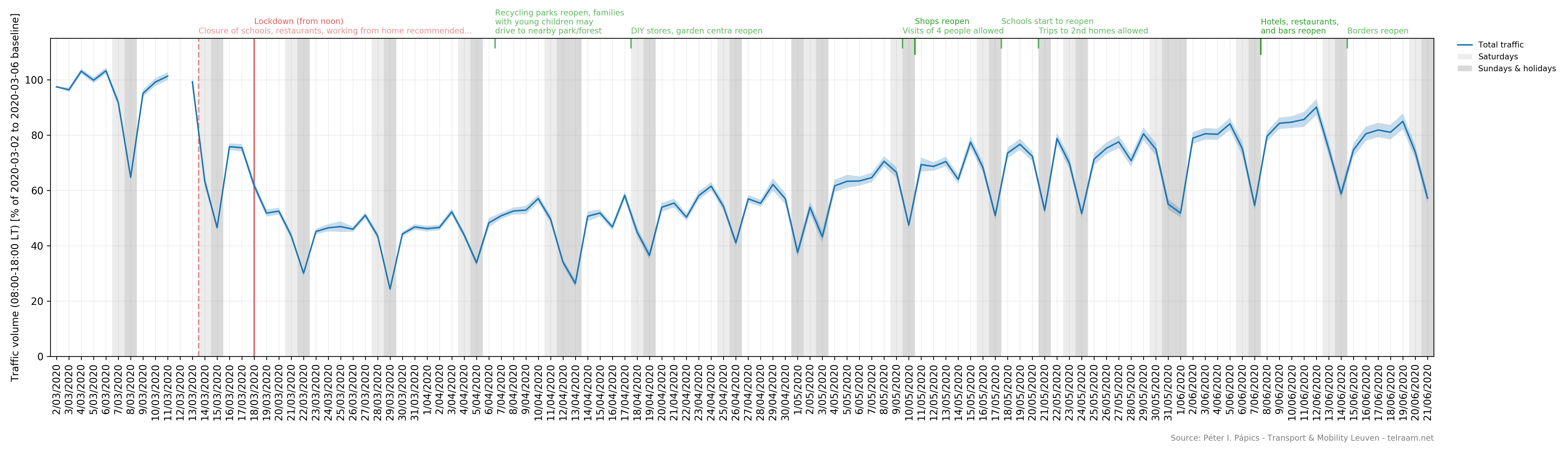
Work went also quite well the past months, as while coding gets boring sometimes, we have been in the news a lot (among others in the VRT, in De Tijd, in De Standaard, in the Knack, and for example with an article in the Verkeersspecialist) thanks to the traffic monitor that I set up using Telraam data, comparing the measured cars, heavy vehicles, cyclists, and pedestrians to the pre-Covid-19 baseline on a daily and weekly basis. I think one of my biggest achievements is getting uncertainty intervals into the national media :) [As this is the wet dream of any data scientist, isn’t it?]

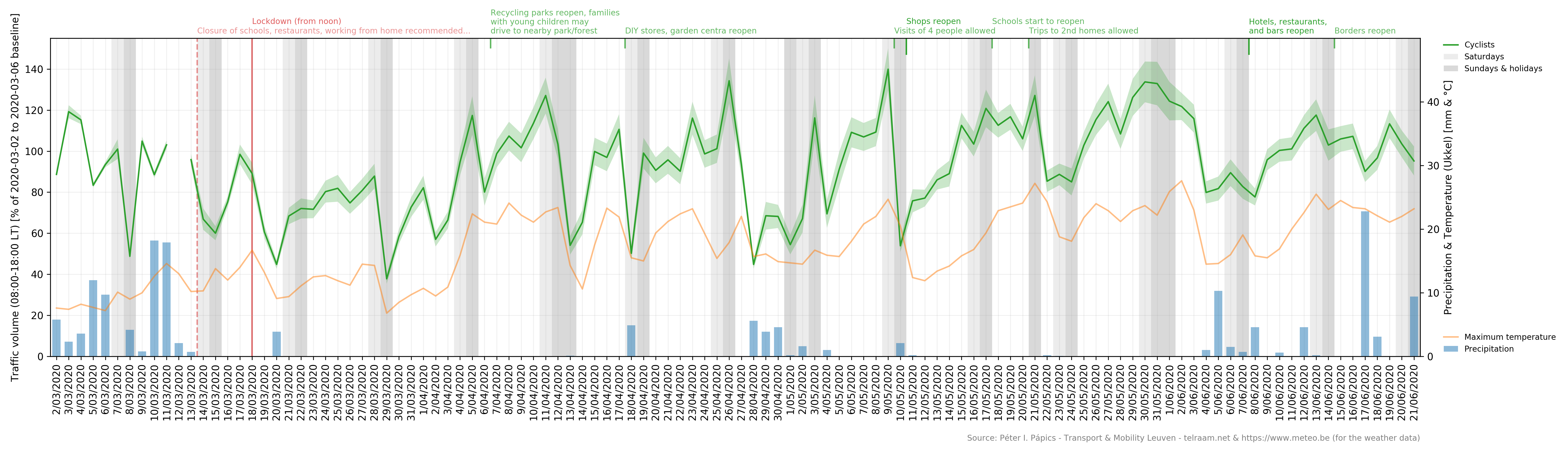
I think it is safe to say that our numbers became the standard when referring to traffic beyond the highways network. I could write a full paper about this, but I will spare you of the boring technical details (here). It’s enough to say that we tracked the initial fall and the slow and long return of traffic on the streets, and we have also seen how strongly leisure oriented cycling correlates with temperature and the absence of rain. Nothing fundamentally surprising, but scientifically sound, precise measurements of our everyday lives and habits, on a level (geographical extent, various modes, temporal resolution, and precision) that has not been done before.

My PhD student (whom I co-supervised the past years, even when I was not working at the university anymore) has defended her thesis, and while for the internal examination we could still meet up with the whole jury in person (followed by a nice dinner), her “public” defense was the first virtual defense at the department (and also the first PhD defense at the Institute of Astronomy of the KU Leuven that is now on YouTube). It went really well (of course), and having a sip of champagne and a piece of chocolate together with her (and my former) supervisor was a nice moment afterwards, even though nobody else could be present. As illustration of a perfect supervisor-student relationship, we both got each other a LEGO to build (and – unrelated – Clio also got me a really nice set to cheer me up when I was feeling really down, which we build up together on a less sunny weekend).

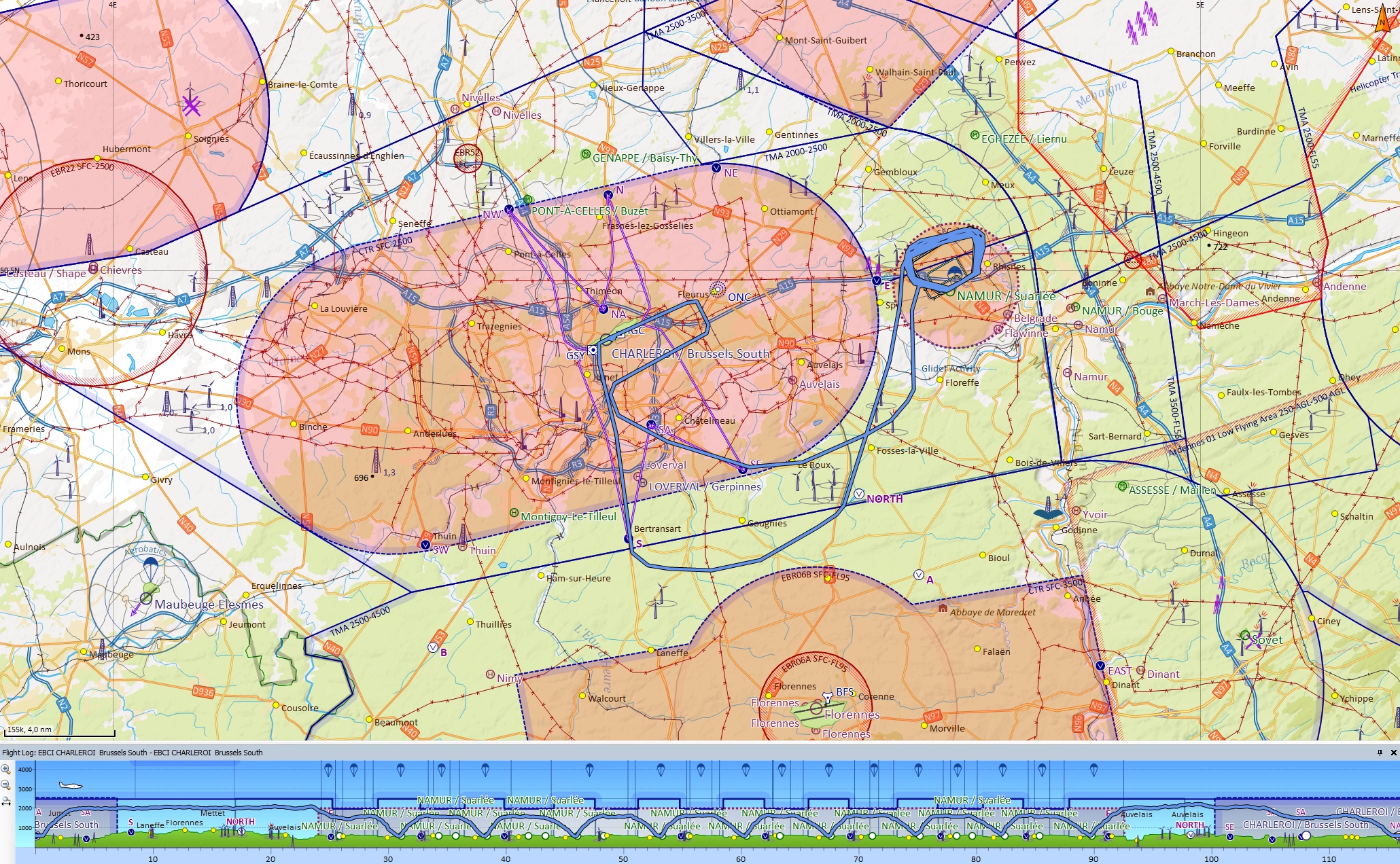
While I could not fly in real life, I spent quite some time (and that is a clear understatement) to create a very precise model of the airport of Charleroi for the flight simulator (X-Plane 11). Instead of listing all the features here (but it has a hand-crafted terrain model, extremely precise markings and lights, taxiway signs, and even some custom 3D models – which took me back to SketchUp after quite some years -, including the iconic first floor facade of the passenger terminal), I will just link the download page of the scenery for the curious readers. It has been very popular among fellow simmers, it is currently within the 20 most popular scenery downloads of the last month. It feels pretty much like the real thing, it is a shame that I can not fly with a Sonaca 200 in the simulator (and making a plane is a bit more complex than making an airport, so no thank you), that would really help in practising some flows and procedures. Sometimes I really hate my perfectionism, because I keep finding things to improve upon, which on one hand is something I like to do, but on the other hand it takes time away from actually just using the scenery.

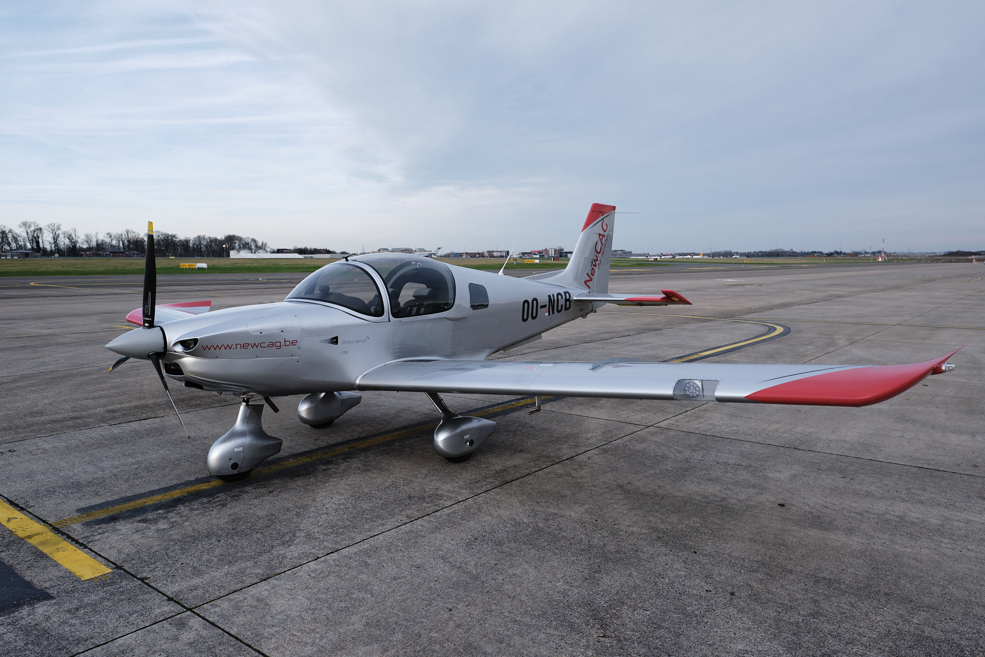
Finally, for the rest of the lockdown news, we have seen the “train” of Starlink satellites on the evening sky (and even recorded the view), and also managed to find a game on PlayStation that we can sometimes play together (Minecraft Dungeons). Two weeks ago on Friday I was finally back in the air (then last Saturday too), so expect some flight training related posts in the near future (since I can barely think of anything else than flying since then).

Road to the PPL: Up into the sky and back down to Earth

During February and March I had four more flight training sessions at EBCI (Charleroi), bringing up my total flight time to 7 hours and 36 minutes (after 6 flights). (This sounds so little like this, it’s basically the amount of time I have to work on a single day, wow. No offence to my work, but I remember these hours slightly more vividly.) It happens that I flew with all the four different Sonaca 200 planes my flight school has, including the brand new OO-NCD (or for my non aviation inclined readers, this is pronounced as Oscar Oscar November Charlie Delta, which had only 22 hours of air time when I sat in it; unfortunately I can not report the presence of a new-plane-smell anymore). I also flew with three different instructors, which definitely helps in getting feedback from people with slightly different approaches (and yes, I have my favourites already, but in general I am very happy with everyone I have flown with so far).

There is way too much stuff in my flight bag already, so I am not carrying my Fujifilm X-T3 with me anymore (even though I would love to take better pictures here and there, but there is simply not enough space or time for it), but I have installed a GoPro camera in the cockpit for these flights. For Flight 3, I had my old GoPro 4 Silver as a test, to see how useful or interesting having a recording of my training is, but then I bought a new GoPro 8, which – thanks to the amazing image stabilisation features – provides a perfectly vibration-free result (in 4K – I don’t even own a 4K screen, but this is 2020, people). By Flight 6 I also had the tech to record the radio communication too, but I messed up the settings so instead of having the recording of me talking to the air traffic controllers of an international airport or listening to the great comments of my flight instructor, I got one and a half hour of video without sound. Anyway, I think I know where I made the mistake, and it should be all good the next time (whenever it will be – thanks Obama Covid-19!).

I have posted the most interesting parts of the flights online (edited in DaVinci Resolve 16) on my YouTube “Channel”, with timestamps and more detailed comments in the descriptions, so I will not go over everything here, just have a summary of what I learned (click to the videos for more). Flight 3 started with my first unassisted take-off, then we did climbing and descending turns.


During Flight 4 we did high-power low-speed climbing turns and low-power descending turns (to feel the different rudder input necessary for a balanced flight in these situations), then we experienced slow flight (flying at and around the speed associated with minimum drag). I had my first transmissions on the radio (talking to Ground and Tower until the take-off point as a start). [You can compare the quality of the first two videos, amazing how stable the new GoPro is, right?]


Flight 5 was mainly power-off stalls in various flap configurations (first clean, then take-off, and landing). At the end I finally got to make a full approach and landing on my own, it was great. Now I did all the radio communication except for the phase between returning to the CTR (the control zone of Charleroi) and landing.


Flight 6 was the best training so far. We headed over to EBNM (Namur) for my first circuits and touch-and-gos (meaning that a landing is immediately followed by a take-off, without stopping). EBNM has a 690 meter long and 25 m wide asphalt runway, which felt very different to the huge runway at EBCI (2405 m x 45 m), but it was a very good exercise. I did 7 landings and 2 (planned) go-arounds, so 9 circuits (or patterns), before heading back to EBCI where I had my 8th landing of the day. Here and there the wind was a bit gusty, and there was a light, but variable crosswind too, so some approaches were more challenging than others.

I did all the radio communication until the start of the touch-and-gos, but from then on I had enough to do with flying and navigating (so my instructor took over the radio there, until we were back on the ground at EBCI). This is completely normal at this point during the training. It was an extremely rewarding training with a very steep learning curve, and I managed some very good landings in the second half of it. By now I am also familiar with all the visual reference points that lie to the South of the runway (since we have never went to the North so far). It was also the most tiring flight of my training so far, not only because it was very long (almost two hours), but also because it was very active, there was barely any straight and level flying, there was always something to do. I loved it. (On a side note, EBNM was the first airport I modelled in detail for X-Plane 11, so it was great to finally visit it in real life too!)


Unfortunately Covid-19 screwed up everything, so no flying in the foreseeable future :( Normally I would have had my security briefing at Charleroi today to get a badge to the airport, and I had training flights booked for every week until the first Sunday of April… Time to proceed with studying the theory and flying in the simulator I guess.

Purple hair

I have not lost a bet, and I am not trying to send a message or support a movement, I simply felt like trying something new out, so I (with some practical help from Clio) coloured my hair purple. If there is anything I would like to say is this: looks do not matter. Not hair colours, nor skin colours. I am still the same person, nothing has changed, but my hair colour. And it will probably change in the future too ;)

Trans Pyrenees 2020 – The Route

Four years after crossing the Pyrenees with Willem from East to West (see the relevant posts here), I am going to revisit the region, and bike from the Atlantic Ocean to the Mediterranean Sea with a colleague (Stef). After a few months of low activity levels and motivation, I finally got back into the sport around the Christmas holidays, and since then I have been commuting by bike again (I love my Brompton), and I have been doing some proper training both inside (Zwift training plan) and outside (when the weather permits, and lately it has been really wet and windy, so less often than I would like to). Of course I needed a proper goal too, because one of the reasons I had lost my motivation to ride last year was the apparent pointlessness of my training, so I definitely wanted to change that. And since I don’t like races and big busy events, what better is there to do than another self supported ride across the Pyrenees!

My planning technique has not really changed since 2016, I still used Strava (even though I had a look at Komoot too, but it had difficulties handling very long routes) and Google Street View to draw up the initial draft, then the availability of hotels set the final stage starts and finishes. I originally wanted to start from San Sebastián, but in the last minute it turned out that the one way extra fee for renting a car in France and dropping it off in Spain (that we need for the drive back to the start on the last day) would have been more than 2000 EUR, so at the end I had to settle with starting in Biarritz (where we finished four years ago).

We have already booked everything (hotels, rental car from Perpignan to Biarritz, long-term parking in Biarritz), so now we just need to train. Being in a good shape will be definitely necessary, because while this time we will have a rest day in the middle, there will be much more climbing than the last time… The final route can be seen below.

It is a total of 993 km, and 25601 metres of elevation gain over 32 (+1) cols (excluding the rest day). An overview of the elevation profile of the whole route can be seen below. (The climb categories were calculated following the discussion presented here.)

Now here is a detailed overview of the planned stages with distances, elevation gains, maps, profiles, and a list of cols for each day:

  • June 10:
    Drive to Biarritz.
  • June 11:
    On the morning we drive to the airport, where we have long-term parking booked, and start from there.
    Stage 1) Biarritz – Saint-Jean-Pied-de-Port: 125 km | 2498 m+ (Map / Profile)
    – Puerto de Otxondo [570 m] Cat 2 (8.2 km @ 5.7%)
    – Puerto de Artesiaga [984 m] Cat 2 (12.8 km @ 5.7%)
    – Collado de Urkiaga [915 m] Cat 4 (6.9 km @ 3.2%)
  • June 12:
    Stage 2) Saint-Jean Pied-de-Port – Anso: 108 km | 3429 m+ (Map / Profile)
    – Col de Burdincurutcheta [1135 m] Cat 1 (9.0 km @ 8.8%)
    – Col de Bagargi [1327 m] Cat 3 (6.5 km @ 4.9%)
    – Port de Larrau [1578 m] HC (14.3 km @ 7.6%)
    – Puerto de Laza [1129 m] Cat 3 (3.4 km @ 6.1%)
    – Puerto de Matamachos [1148 m] Cat 2 (4.6 km @ 6.7%)
  • June 13:
    Stage 3) Anso – Oloron-Sainte-Marie: 104 km | 2158 m+ (Map / Profile)
    – Alto de Zuriza [1290 m] Cat 3 (13.8 km @ 3.2%)
    – Col de la Pierre St Martin [1766 m] Cat 1 (14.3 km @ 5.3%)
    – Col de la Hourcère [1440 m] Cat 3 (4.8 km @ 4.5%)
    – Col de Bugalaran [498 m] Cat 3 (3.3 km @ 6.9%)
  • June 14:
    Stage 4) Oloron-Sainte-Marie – Luz-Saint-Sauveur: 112 km | 3275 m+ (Map / Profile)
    – Col de Marie Blanque [1035 m] Cat 1 (9.1 km @ 7.8%)
    – Col d’Aubisque [1709 m] HC (17.0 km @ 7.0%)
    – Col du Soulor [1474 m] Cat 3 (1.9 km @ 5.0%)
    – Col des Bordères [1156 m] Cat 2 (4.2 km @ 6.9%)
  • June 15:
    Stage 5) Luz-Saint-Sauveur – Bagnères-de-Luchon ♛: 114 km | 3874 m+ (Map / Profile)
    – Col du Tourmalet [2115 m] HC (19.0 km @ 7.4%)
    – Hourquette d’Ancizan [1564 m] Cat 2 (16.6 km @ 4.3% – including a short descent)
    – Col de Val Louron-Azet [1580 m] Cat 1 (10.7 km @ 7.3%)
    – Montée de Peyragudes [1645 m] Cat 1 (9.6 km @ 7.3%)
    (- Col de Peyresourde [1569 m] practically in the descent)
  • June 16:
    Rest day: we will probably still bike, something short and flat, to keep the blood flowing and to get the total distance beyond the thousand kilometre mark ;) But the main plan is mostly staying horizontal, and eating as much as possible.
  • June 17:
    Stage 6) Bagnères-de-Luchon – Castillon-en-Couserans: 100 km | 2775 m+ (Map / Profile)
    – Port de Balès [1755 m] Cat 1 (18.8 km @ 5.9%)
    – Col de Menté [1349 m] HC (9.3 km @ 9.0%)
    – Col de Portet d’Aspet [1069 m] Cat 1 (4.3 km @ 9.5%)
  • June 18:
    Stage 7) Castillon-en-Couserans – Ax-les-Thermes: 137 km | 3667 m+ (Map / Profile)
    – Col de la Core [1395 m] Cat 1 (14.2 km @ 5.8%)
    – Col de Latrape [1110 m] Cat 2 (5.8 km @ 7.4%)
    – Col d’Agnes [1570 m] Cat 1 (10.3 km @ 8.0%)
    – Port de Lers [1517 m] Cat 3 (4.7 km @ 5.2%)
    – Pas de Souloumbrie [911 m] Cat 3 (6.3 km @ 5.5%)
  • June 19:
    Stage 8) Ax-les-Thermes – Prades: 102 km | 2717 m+ (Map / Profile)
    – Col de Pailheres [2001 m] HC (17.1 km @ 6.8%)
    – Col des Aychides [1008 m] Cat 3 (6.3 km @ 4.1%)
    – Col de Jau [1506 m] Cat 1 (17.9 km @ 5.8%)
  • June 20:
    Stage 9) Prades – Perpignan: 91 km | 1208 m+ (Map / Profile)
    – Col de Palomère [1036 m] Cat 2 (24.4 km @ 3.2% – including a short descent)
    Pick up the rental car in Perpignan and drive to Biarritz, where we stay for the night.
  • June 21:
    Drive home.

Road to the PPL: The first flights of my training

Last month I had the first two flights of my PPL training at Charleroi (EBCI). I was supposed to have a third one too, but that was unfortunately cancelled due to Belgium being under a think layer of fog for almost a week… Currently I have three more flights booked for February, but of course winter weather can often be unsuitable for VFR (flying by visual flight rules), so having just two of these go through would probably be a big success already. I hope during the summer it will be easier to book lessons (with longer days, better instructor availability, and better weather chances).

Before the first flight I still had to buy some basic equipment, such as a headset, checklists, a VFR map of Belgium, and a kneeboard (and later I still got a nicer headset case, a fuel tester, a plotter, an E6-B flight computer, and a Leatherman multitool to complete my flight bag). And of course as a data-geek I also got a flight-planner/tracker app for my iPhone (SkyDemon) so I have a log of all my future flights at the same place.

Even though the first flight itself was more of a familiarisation flight (procedures, checklists, all the pre-flight paperwork, primary and secondary effects of the controls, important visual navigation points around Charleroi, straight and level flight, use of the trim), I went very well prepared (I studied all the relevant theory modules), so we did some basic manoeuvres too (a few turns, nothing special), and I had no problem maintaining course and altitude. Of course the landing, take-off, and radio communication was done by my instructor, as a demonstration.

I fly a Sonaca 200, a low-wing cantilever monoplane made from aluminium alloy (in Belgium). It has an enclosed cabin with two side-by-side seats, it is powered by a 115 hp Rotax 914 engine (a turbo-charged, four-stroke, four-cylinder, horizontally opposed aircraft engine with air-cooled cylinders and water-cooled cylinder heads), and has a fixed tricycle landing gear. It has a propeller made out of three composite blades and a cruise speed of 213 km/h. Air Academy New CAG has currently three of them (with one more coming soon), OO-NCA, OO-NCB, and OO-NCC. They have an analogue instrument panel except for the digital engine monitoring system (EMS) display. All in all a very basic, but reliable, safe, and comfortable general aviation (training) plane.

After the first flight I have made a Google Sheet for the weight and balance calculations, so I just need to pick the aircraft, fill in the fuel, passenger and luggage weights, and I get all the values (plus load limit checks) that need to be filled into the pre-flight documents. (In the example below input fields are marked with a blue background, there is a red warning that the take-off mass and moment combination would be outside of the safety limits – in this case the centre of gravity would be just a bit too forward and moving the luggage to the rear bag area would solve the issue -, and a green confirmation that the baggage is within the limits.) Nice and convenient. I also added each aircraft to the database of SkyDemon, with not only weight and balance, but proper flight performance data too, so I could also use that for the weight and balance calculations and flight planning in the future (when we get to the point of cross-country and navigation flights).

The second flight (see log on the map below) was much more proactive, I did the full pre-flight checklist (including external checks), taxiing (movement on the ground), and even the take-off by myself. Then I did again some straight and level flying out of the control zone, followed by climbing and descending (attitude-power-trim and power-attitude-trim procedure) sandwiched between various turn exercises. The landing was still 50% demonstration, but my instructor said that next time I would have full control, since I am doing so well :)

I wanted to install a GoPro for the third flight, but winter got in the way, so this will have to wait, but soon I will give some insight to the cockpit too. Looking forward to my next flights!